
Simulation-Based Evaluation of LiDAR–Photogrammetry Fusion via NeRF Reconstruction and ICP Registration in Urban Scenes
DOI:
https://doi.org/10.58190/ijamec.2026.162Keywords:
NeRF, LiDAR–Photogrammetry Fusion, Point-Cloud Registration, Simulation, Urban ScenesAbstract
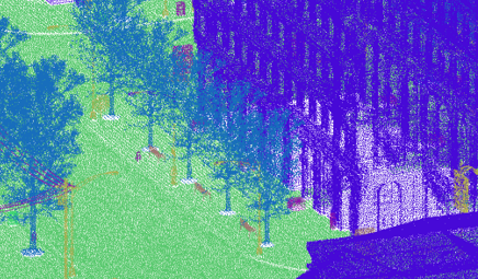
Reliable integration of LiDAR and photogrammetric point clouds is essential for high-precision 3D mapping, yet systematic evaluations of fusion accuracy under controlled conditions remain limited. This study presents a simulation-based assessment framework for LiDAR–photogrammetry fusion using a neural radiance field (NeRF) representation and iterative closest point (ICP) registration. Experiments were conducted in the CARLA simulator (Town 10), where a drone-mounted multi-sensor platform (RGB, LiDAR, GPS, IMU) generated spatially aligned datasets. Photogrammetric reconstructions were produced using the Nerfstudio–Nerfacto pipeline with varied architectural and sampling configurations to analyze their impact on cross-modal registration. Quantitative evaluation employed Chamfer and cloud-to-cloud (C2C) distances to assess NeRF reconstruction fidelity, and ICP root-mean-square error (RMSE), inlier fitness, and runtime to evaluate registration performance. Results show that tuning NeRF’s hidden dimensions and sampling levels yields up to 25% lower ICP RMSE and faster convergence across object categories. The proposed framework enables reproducible benchmarking of LiDAR–photogrammetry fusion and provides a foundation for extending NeRF-based methods to real-world urban mapping scenarios.
Downloads
References
[1] T. Ren and H. Jebelli, “Efficient 3D robotic mapping and navigation method in complex construction environments,” Computer‐Aided Civil and Infrastructure Engineering, vol. 40, no. 12, pp. 1580-1605, 2025.
[2] R. Maskeliünas, S. Maqsood, "Lightweight Attention-Based Framework for Semantic Segmentation and Compression of 3D LiDAR Data", SETSCI Conference Proceedings, vol. 22, pp. 7-10, 2025.
[3] P. Chen, X. Zhao, L. Zeng, L. Liu, S. Liu, L. Sun, Z. Li, H. Chen, G. Liu, Z. Qiao, Y. Qu, D. Xu, L. Li, and L. Li, “A Review of Research on SLAM Technology Based on the Fusion of LiDAR and Vision,” Sensors, vol. 25, no. 5, 1447, 2025.
[4] R. Maskeliūnas, S. Maqsood, M. Vaškevičius, and J. Gelšvartas, “Fusing LiDAR and photogrammetry for accurate 3D data: A hybrid approach,” Remote sensing, vol. 17, no. 3, pp. 1-27, 2025.
[5] Y. Ye, J. Shan, L. Bruzzone, and L. Shen, “Robust registration of multimodal remote sensing images based on structural similarity,” IEEE Transactions on Geoscience and Remote Sensing, vol. 55, no. 5, pp. 2941-2958, 2017.
[6] K. Istenič, N. Gracias, A. Arnaubec, J. Escartín, and R. Garcia, “Scale accuracy evaluation of image-based 3D reconstruction strategies using laser photogrammetry,” Remote Sensing, vol. 11, no. 18, 2093, 2019.
[7] R. Maskeliūnas, and S. Maqsood, “Hybrid attention-based PTv3-SE model for efficient point cloud segmentation,” Remote Sensing Applications: Society and Environment, vol. 41, 101891, 2026.
[8] M. Gassilloud, B. Koch, and A. Göritz, “Occlusion mapping reveals the impact of flight and sensing parameters on vertical forest structure exploration with cost-effective UAV based laser scanning,” International Journal of Applied Earth Observation and Geoinformation, vol. 139, 104493, 2025.
[9] J. Yang, H. Li, D. Campbell, and Y. Jia, “Go-ICP: A globally optimal solution to 3D ICP point-set registration,” IEEE transactions on pattern analysis and machine intelligence, vol. 38, no. 11, pp. 2241-2254, 2015.
[10] C. H. Lin, W. C. Ma, A. Torralba, and S. Lucey, “Barf: Bundle-adjusting neural radiance fields,” In Proceedings of the IEEE/CVF international conference on computer vision, pp. 5741-5751, 2021.
[11] Y. Chen and G. H. Lee, “DReg-NeRF: Deep Registration for Neural Radiance Fields,” in Proc. IEEE/CVF International Conference on Computer Vision (ICCV), 2023.
[12] A. T. D. S. Ferreira, C. H. Grohmann, M. C. H. Ribeiro, M. S. T. Santos, R. C. de Oliveira, and E. Siegle, “Beach surface model construction: A strategy approach with structure from motion-multi-view stereo,” MethodsX, vol. 12, 102694, 2024.
[13] B. Mildenhall, P. P. Srinivasan, M. Tancik, J. T. Barron, R. Ramamoorthi, and R. Ng, “Nerf: Representing scenes as neural radiance fields for view synthesis,” Communications of the ACM, vol. 65, no. 1, pp. 99-106, 2021.
[14] Y. Li and X. Xiao, “Deep Learning-Based Fusion of Optical, Radar, and LiDAR Data for Advancing Land Monitoring,” Sensors, vol. 25, no. 16, 4991, 2025.
[15] S. Xu, Q. Xue, Z. Chen, S. Fei, and H. Gao, “Complementary information-guided interactive fusion network for HSI and LiDAR data joint classification,” Expert Systems with Applications, vol. 298, 129549, 2026.
[16] N. Xu, R. Qin, and S. Song, “Point cloud registration for LiDAR and photogrammetric data: A critical synthesis and performance analysis on classic and deep learning algorithms,” ISPRS Open J. Photogramm. Remote Sens., vol. 8, p. 100032, 2023.
[17] K. Ma, F. Yan, S. Li, G. Huang, X. Jia, F. Wang, and L. Chen, “Low-Overlap Registration of Multi-Source LiDAR Point Clouds in Urban Scenes Through Dual-Stage Feature Pruning and Progressive Hierarchical Methods,” Remote Sensing, vol. 17, no. 17, 2938, 2025.
[18] J. Wang and H. Xu, “Cross-modal deep learning framework for 3D reconstruction and information integration of Zhejiang wood carving heritage,” Scientific Reports, vol. 16, 465, 2025.
[19] M. Ramezani, Y. Wang, M. Camurri, D. Wisth, M. Mattamala, and M. Fallon, “The Newer College Dataset: Handheld LiDAR, Inertial and Vision with Ground Truth,” in Proc. IEEE/RSJ Int. Conf. Intell. Robots Syst. (IROS), Las Vegas, NV, USA, Oct. 2020, pp. 4353–4360.
[20] R. Maskeliūnas, S. Maqsood, M. Vaškevičius, and J. Gelšvartas, “Hybrid deep learning and geometric algorithms for individual object detection in urban LiDAR point clouds,” International Journal of Remote Sensing, vol. 46, no. 23, pp. 9118–9156, 2025.
[21] A. Dosovitskiy, G. Ros, F. Codevilla, A. Lopez, and V. Koltun, “CARLA: An open urban driving simulator,” In Conference on robot learning, pp. 1-16, 2017.
[22] T. Roosendaal and Community, Blender 3.0 User Manual, Blender Foundation, 2021.
Downloads
Published
Issue
Section
License
Copyright (c) 2026 International Journal of Applied Methods in Electronics and Computers

This work is licensed under a Creative Commons Attribution-ShareAlike 4.0 International License.